TEST_CF_UGRID3
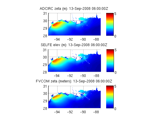
Compare water levels from 3 different unstructured grid models that use UGRID conventions (http://bit.ly/cf_ugrid), allowing comparison with no model specific code
Contents
Datasets
ADCIRC
titl{1}='ADCIRC';
uris{1}='http://testbedapps-dev.sura.org/thredds/dodsC/in/und/adcirc/ike/ultralite/lr/vardrag/nowave/3d';
vars{1}='zeta';
time=[2008 9 13 06 0 0];

%%% SELFE
titl{2}='SELFE';
uris{2}='http://testbedapps.sura.org/thredds/dodsC/inundation/selfe/ike/3Dvrwoww';
vars{2}='elev';

%%% FVCOM
titl{3}='FVCOM';
uris{3}='http://testbedapps.sura.org/thredds/dodsC/inundation/FVCOM/ike/3Dvrwoww';
vars{3}='zeta';
Setup figure parameters
bounding box for figures
ax=[-95.4519  -87.3856   28.0   31.0];

%%% color range for figures
cax=[0 5];
There is nothing model specific in the loop below!
for i=1:length(uris)
  tic
  % Initialize dataset object
  nc=ncgeodataset(uris{i});
  %get geovariable object
  zvar=nc.geovariable(vars{i});
  % Find the coordinate variables
  lon=zvar.getlondata(:);
  lat=zvar.getlatdata(:);
  tdat=zvar.timewindowij(time);
  itime=tdat.index;
  % read data at specified time step for all nodes
  zeta=zvar.data(itime,:);
  % get mesh variable name (inference array)
  gvar_name=zvar.attribute('mesh');
  gridvar=nc.geovariable(gvar_name);
  % find connectivity array variable from mesh variable
  trivar_name=gridvar.attribute('face_node_connectivity');

  % get connnectivity array data
  tri=nc{trivar_name}(:);
  [m,n]=size(tri);
  % check/fix orientation of connectivity array
  if m==3,
    tri=tri.';
  elseif n~=3
    disp('Error:Currently handling triangles only');return
  end
  subplot(length(uris),1,i)
  trisurf(tri,lon,lat,zeta);shading interp;view(2);colorbar;...
    axis(ax);caxis(cax);...
    title(sprintf('%s %s (%s): %sZ',titl{i},vars{i},...
    zvar.attribute('units'),datestr(tdat.time)));...
    % set aspect ratio for lon/lat plot based on mean latitude
  set (gca, 'DataAspectRatio', [1 cos(mean(lat(:))*pi/180) 1] );

  toc
end
Elapsed time is 72.348191 seconds.
Elapsed time is 75.959380 seconds.
Elapsed time is 66.551909 seconds.
